CropTime OSU weather data
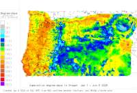
CropTime OSU Weather Data and Phenology/Degree-Day Models
All Available Networks - other tables for OR include: AGRIMET, CWOP/APRS, METAR, see our homepage.
Interactive degree-day maps
CropTime OSU base 32 degree-days to date
Degree-day & Phenology Model Calculator
 Also try the full-featured calculator/DD model (NW states only)
Select model: 
Thresholds: lower: °F   upper: °F (or celsius °C:)
  Calc. method:
Start (biofix) date:   End date:   
Forecast zipcode or city, state:
Table - to SORT click on headers:
# Location
click to go to DD model interface
 
County

Station code,
links to
NWS recent
weather

Links to
NWS fore-
casts
 
Net-
work
Elev. (ft)
 
Lat./ Long.
(Dec. Deg.)
 
Max-min temperature data and degree-days
(click radio button to calc.)

30 yr
avgs
1 (NW C POINT) KIRTLAND Jackson
BCKIRT
map
   Zone
Digital
Medford Bear Creek Network
1198
 42.43333
-122.93333
2013
2012
2010
-
2 Albany17 Benton
KORALBAN17
map
   Zone
Digital
Weather Underground
216
 44.63556
-123.06889
2013
2012
2011
2010
AVG
3 Albany Benton
KORALBAN1
map
   Zone
Digital
Weather Underground
219
 44.63056
-123.10806
2013
2012
2011
2010
2009
AVG
4 Aloha CW4176 Washington
C4176
map
   Zone
Digital
CWOP/APRS
210
 45.48028
-122.87278
2013
2012
2011
2010
2009
AVG
5 Aloha Washington
KORALOHA11
map
   Zone
Digital
Weather Underground
173
 45.48250
-122.88889
2013
2012
2011
2010
AVG
6 ANNIE SPRINGS Douglas
ANSO3
map
   Zone
Digital
SNOTEL
6020
 42.86972
-122.17000
2013
2012
2011
2010
2009
AVG
7 ASHLAND Jackson
KS03
map
   Zone
Digital
NCAWOS
1885
 42.19028
-122.66056
2013
2012
2011
2010
2009
AVG
8 Aumsville Marion
KORAUMSV3
map
   Zone
Digital
Weather Underground
380
 44.82806
-122.86167
2013
2012
2011
2010
AVG
9 Aurora State Airport Clackamas
KUAO
map
   Zone
Digital
METAR
194
 45.24889
-122.76556
2013
2012
2011
2010
2009
AVG
10 AURORA Clackamas
ARAO
map
   Zone
Digital
AGRIMET
141
 45.28167
-122.75028
2013
2012
2011
2010
2009
AVG
11 Beavercreek DW5586 Clackamas
D5586
map
   Zone
Digital
CWOP/APRS
1407
 45.24472
-122.43500
2013
2012
AVG
12 Beaverton CW3453 Washington
C3453
map
   Zone
Digital
CWOP/APRS
253
 45.54556
-122.85000
2013
2012
2011
2009
AVG
13 Beaverton DW6123 Washington
D6123
map
   Zone
Digital
CWOP/APRS
295
 45.51083
-122.79417
2013
2012
AVG
14 Beaverton Washington
KORBEAVE37
map
   Zone
Digital
Weather Underground
659
 45.44806
-122.85417
2013
2012
2011
2010
AVG
15 BELKNAP SPRINGS AMz Linn
BELO3
map
   Zone
Digital
COOP
2349
 44.28306
-122.03306
2013
2012
2011
2010
2009
AVG
16 BIG RED MOUNTAIN Jackson
BRMO3
map
   Zone
Digital
SNOTEL
6250
 42.05000
-122.85000
2013
2012
2011
2010
2009
AVG
17 BIGELOW CAMP Josephine
BGCO3
map
   Zone
Digital
SNOTEL
5120
 42.07972
-123.34000
2013
2012
2011
2010
2009
AVG
18 BLACK ROCK Lane
OKFO3
map
   Zone
Digital
RAWS
4891
 43.52806
-121.81556
2013
2012
2011
2010
2009
AVG
19 Boardman CW1075 Benton
C1075
map
   Zone
Digital
CWOP/APRS
322
 45.84167
-119.69694
2013
2012
2011
2010
2009
AVG
20 Boring DW4869 Multnomah
D4869
map
   Zone
Digital
CWOP/APRS
1765
 45.44139
-122.36611
2013
2012
AVG
21 Boring Multnomah
KORBORIN2
map
   Zone
Digital
Weather Underground
662
 45.45667
-122.31056
2013
2012
2011
2010
AVG
22 BOULDER CREEK Marion
BOFO3
map
   Zone
Digital
RAWS
3570
 44.72167
-122.00306
2013
2012
2011
2010
2009
AVG
23 BRIDAL Multnomah
UP112
map
   Zone
Digital
UPR
50
 45.54139
-122.23750
2013
2012
2011
2010
2009
AVG
24 Brightwood Weigh Stn U Clackamas
ODT15
map
   Zone
Digital
ODOT
1070
 45.37556
-122.03528
2013
2012
2011
2010
2009
AVG
25 BRUSH CREEK Linn
BRUO3
map
   Zone
Digital
RAWS
2130
 44.28417
-122.84917
2013
2012
2011
2010
2009
AVG
26 BUCKEYE Douglas
PKFO3
map
   Zone
Digital
RAWS
2264
 43.03639
-122.65528
2013
2012
2011
2010
2009
AVG
27 BUCKHORN SPRINGS Jackson
BUCO3
map
   Zone
Digital
RAWS
2780
 42.12056
-122.56389
2013
2012
2011
2010
2009
AVG
28 BURNT RIDGE Douglas
BNFO3
map
   Zone
Digital
RAWS
2955
 43.20278
-123.71750
2013
2012
2011
2010
2009
AVG
29 CALVERT PEAK Douglas
CVFO3
map
   Zone
Digital
RAWS
3822
 42.77917
-123.73444
2013
2012
2011
2010
2009
AVG
30 Camas Mtn 42 MP 57 Douglas
ODT77
map
   Zone
Digital
ODOT
1450
 43.06500
-123.64944
2013
2012
AVG
31 Canby CW5416 Clackamas
C5416
map
   Zone
Digital
CWOP/APRS
100
 45.27944
-122.68750
2013
2012
2011
2010
2009
AVG
32 Canby CW9654 Clackamas
C9654
map
   Zone
Digital
CWOP/APRS
158
 45.26917
-122.69139
2013
2012
2011
2010
2009
AVG
33 Canby W7OBH Clackamas
AS522
map
   Zone
Digital
CWOP/APRS
164
 45.25667
-122.68444
2013
2011
2010
AVG
34 Canby Marion
KORCANBY4
map
   Zone
Digital
Weather Underground
173
 45.21000
-122.72778
2013
2012
2011
2010
AVG
35 Canemah (OR 99E MP 14) Clackamas
ODT63
map
   Zone
Digital
ODOT
125
 45.34194
-122.63472
2013
2012
2011
2010
2009
AVG
36 CASCADE SUMMIT Lane
CSTO3
map
   Zone
Digital
SNOTEL
4880
 43.59000
-122.06000
2013
2012
2011
2010
2009
AVG
37 Cave Jctn Josephine
KORCAVEJ2
map
   Zone
Digital
Weather Underground
1325
 42.11167
-123.66889
2013
2012
2011
2010
2009
AVG
38 Central Point CW3932 Jackson
C3932
map
   Zone
Digital
CWOP/APRS
1290
 42.36556
-122.90556
2013
2012
2011
2010
AVG
39 CHARLOTTE RIDGE Lane
CHRO3
map
   Zone
Digital
RAWS
1220
 43.66917
-123.94333
2013
2012
2011
2010
2009
AVG
40 CINNAMON Douglas
CIFO3
map
   Zone
Digital
RAWS
4834
 43.32056
-122.10667
2013
2012
2011
2010
2009
AVG
41 Coos Bay CW5925 Douglas
C5925
map
   Zone
Digital
CWOP/APRS
49
 43.31306
-124.16528
2013
2012
2011
2010
2009
AVG
42 Corbett CW2654 Multnomah
C2654
map
   Zone
Digital
CWOP/APRS
1050
 45.52333
-122.21944
2013
2012
2011
2010
2009
AVG
43 Corbett CW2664 Multnomah
C2664
map
   Zone
Digital
CWOP/APRS
659
 45.53111
-122.29167
2013
2012
2011
2010
2009
AVG
44 Corbett DW3605 Multnomah
D3605
map
   Zone
Digital
CWOP/APRS
1755
 45.52083
-122.16111
2013
2012
AVG
45 Cornelius CW9369 Washington
C9369
map
   Zone
Digital
CWOP/APRS
171
 45.51417
-123.06167
2013
2012
2011
2010
2009
AVG
46 Cornelius Washington
KORCORNE1
map
   Zone
Digital
Weather Underground
646
 45.47306
-123.09167
2013
2012
2011
2010
2009
AVG
47 Corvallis CW5709 Benton
C5709
map
   Zone
Digital
CWOP/APRS
239
 44.55111
-123.29111
2013
2012
2011
2010
2009
AVG
48 Corvallis Muni Apt Benton
KCVO
map
   Zone
Digital
METAR
246
 44.50000
-123.28306
2013
2012
2011
2010
2009
AVG
49 Corvallis13 Benton
KORCORVA13
map
   Zone
Digital
Weather Underground
236
 44.54806
-123.29667
2013
2012
2011
2010
AVG
50 Corvallis17 Benton
KORCORVA17
map
   Zone
Digital
Weather Underground
508
 44.60056
-123.27278
2013
2012
2011
2010
AVG
51 Corvallis4 Benton
KORCORVA4
map
   Zone
Digital
Weather Underground
305
 44.59028
-123.29056
2013
2012
2011
2010
2009
AVG
52 Corvallis6 Benton
KORCORVA6
map
   Zone
Digital
Weather Underground
397
 44.59167
-123.30500
2013
2012
2011
2010
2009
AVG
53 CORVALLIS Linn
CRVO
map
   Zone
Digital
AGRIMET
230
 44.63417
-123.18972
2013
2012
2011
2010
2009
AVG
54 CORVALLIS Benton
FNWO3
map
   Zone
Digital
RAWS
308
 44.41806
-123.32528
2013
2012
2011
2010
2009
AVG
55 Crown Point DW6193 Multnomah
D6193
map
   Zone
Digital
CWOP/APRS
751
 45.53861
-122.24417
2013
2012
AVG
56 CURTIN NEAR AMz Lane
CRTO3
map
   Zone
Digital
COOP
515
 43.71667
-123.20000
2013
2012
2011
2010
2009
AVG
57 Dallas CW5404 Polk
C5404
map
   Zone
Digital
CWOP/APRS
282
 44.91778
-123.29556
2013
2012
2011
2010
2009
AVG
58 Dallas CW9822 Polk
C9822
map
   Zone
Digital
CWOP/APRS
459
 44.85944
-123.34194
2013
2012
2011
2010
2009
AVG
59 DALY LAKE Linn
DALO3
map
   Zone
Digital
SNOTEL
3600
 44.52000
-122.09000
2013
2012
2011
2010
2009
AVG
60 Damascus CW9538 Multnomah
C9538
map
   Zone
Digital
CWOP/APRS
640
 45.43167
-122.42694
2013
2012
2011
2010
2009
AVG
61 Damascus DW6099 Multnomah
D6099
map
   Zone
Digital
CWOP/APRS
748
 45.44139
-122.46278
2013
2012
AVG
62 Deadwood KC7RJK3 Lane
AT060
map
   Zone
Digital
CWOP/APRS
400
 44.16778
-123.75167
2013
2012
2011
2010
2009
AVG
63 Detroit Lake Marion
DTRO
map
   Zone
Digital
AGRIMET
1675
 44.72972
-122.17917
2013
2012
2011
2010
2009
AVG
64 DIAMOND LAKE Douglas
DIAO3
map
   Zone
Digital
SNOTEL
5315
 43.18972
-122.14000
2013
2012
2011
2010
2009
AVG
65 Diamond Lk Ore 138 MP Douglas
ODT45
map
   Zone
Digital
ODOT
5260
 43.12667
-122.13194
2013
2012
2011
2010
2009
AVG
66 DORENA DAM COOP ST AM Lane
DODO3
map
   Zone
Digital
COOP
1210
 43.76667
-122.95000
2013
2012
2011
2010
2009
AVG
67 DRAIN AMz Douglas
DRNO3
map
   Zone
Digital
COOP
311
 43.66667
-123.31667
2013
2012
2011
2010
2009
AVG
68 DUGAN (SE TALENT) Jackson
BCDUGA
map
   Zone
Digital
Medford Bear Creek Network
1640
 42.23917
-122.76056
2013
2012
2011
2010
AVG
69 Dundee Yamhill
KORDUNDE1
map
   Zone
Digital
Weather Underground
367
 45.29417
-123.02417
2013
2012
2011
2010
AVG
70 DUNES Lane
DUNO3
map
   Zone
Digital
RAWS
120
 43.95778
-124.11944
2013
2012
2011
2010
2009
AVG
71 EAGLE CREEK Clackamas
EGKO3
map
   Zone
Digital
RAWS
732
 45.36806
-122.33083
2013
2012
2011
2010
2009
AVG
72 Eagle Creek Clackamas
KOREAGLE1
map
   Zone
Digital
Weather Underground
357
 45.34806
-122.36167
2013
2012
2011
2010
2009
AVG
73 EMIGRANT DAM SE ASHLAN Jackson
EMI
map
   Zone
Digital
HYDROMET
2181
 42.16389
-122.60417
2013
2012
2011
2010
2009
AVG
74 EMIGRANT Lk AT DAM @ A Jackson
EMIO3
map
   Zone
Digital
HADS
2042
 42.16389
-122.60417
2013
2012
2011
2010
2009
AVG
75 EMIGRANT Lane
EMFO3
map
   Zone
Digital
RAWS
3840
 43.48306
-122.23028
2013
2012
2011
2010
2009
AVG
76 Enchanted WayS Salem I Marion
ODT47
map
   Zone
Digital
ODOT
500
 44.82389
-123.01833
2013
2012
2011
2010
2009
AVG
77 Eugene AC7TK2 Lane
AR802
map
   Zone
Digital
CWOP/APRS
423
 44.08167
-123.06417
2013
2012
2011
2010
2009
AVG
78 Eugene CW3067 Lane
C3067
map
   Zone
Digital
CWOP/APRS
427
 44.06778
-123.05944
2013
2012
2010
2009
AVG
79 Eugene DW1439 Lane
D1439
map
   Zone
Digital
CWOP/APRS
810
 43.94194
-123.21694
2013
2012
2011
2010
2009
AVG
80 Eugene KC7RJK2 Lane
AR232
map
   Zone
Digital
CWOP/APRS
381
 44.10889
-123.14889
2013
2012
2011
2010
2009
AVG
81 Eugene KN1X Lane
AT272
map
   Zone
Digital
CWOP/APRS
433
 44.03694
-123.12417
2013
2012
2011
2010
AVG
82 Eugene Mahlon Sweet Fl Lane
KEUG
map
   Zone
Digital
METAR
364
 44.13306
-123.21417
2013
2012
2011
2010
2009
AVG
83 EVANS CREEK Jackson
EVFO3
map
   Zone
Digital
RAWS
3200
 42.59778
-123.10500
2013
2012
2011
2010
2009
AVG
84 FIELDS Lane
FEFO3
map
   Zone
Digital
RAWS
3373
 43.68056
-122.30167
2013
2012
2011
2010
2009
AVG
85 FISH HATCHERY AMz Lane
OKRO3
map
   Zone
Digital
COOP
1620
 43.73306
-122.43306
2013
2012
2011
2010
2009
AVG
86 FISH LK Jackson
FISO3
map
   Zone
Digital
SNOTEL
4665
 42.38000
-122.35000
2013
2012
2011
2010
2009
AVG
87 Florence CW2527 Lane
C2527
map
   Zone
Digital
CWOP/APRS
46
 43.97972
-124.09472
2013
2012
2011
2010
2009
AVG
88 Florence Muni Apt Lane
K6S2
map
   Zone
Digital
METAR
52
 43.98278
-124.11139
2013
AVG
89 FOOTHILL (NE MEDFORD) Jackson
BCFOOT
map
   Zone
Digital
Medford Bear Creek Network
1404
 42.40417
-122.81250
2013
2012
2011
2010
AVG
90 FOREST GROVE AMz Washington
FOGO3
map
   Zone
Digital
COOP
190
 45.51667
-123.10000
2013
2012
2011
2010
2009
AVG
91 Forest Grove N7NKE Washington
AS436
map
   Zone
Digital
CWOP/APRS
200
 45.54139
-123.13167
2013
2012
2011
2010
2009
AVG
92 FOREST GROVE Washington
FOGO
map
   Zone
Digital
AGRIMET
180
 45.55306
-123.08333
2013
2012
2011
2010
2009
AVG
93 Fremont Brdg W I405 MP Multnomah
ODT10
map
   Zone
Digital
ODOT
270
 45.53667
-122.68417
2013
2012
2011
2010
2009
AVG
94 Glide DW1628 Douglas
D1628
map
   Zone
Digital
CWOP/APRS
755
 43.32000
-123.05972
2013
2012
2011
2010
2009
AVG
95 GOODWIN PEAK Lane
GPFO3
map
   Zone
Digital
RAWS
1800
 43.92806
-123.89028
2013
2012
2011
2010
2009
AVG
96 GRANDAD Douglas
GDFO3
map
   Zone
Digital
RAWS
2900
 43.41556
-122.57694
2013
2012
2011
2010
2009
AVG
97 GRANTS PASS AMz Josephine
GPSO3
map
   Zone
Digital
COOP
964
 42.41667
-123.31667
2013
2012
2011
2010
2009
AVG
98 Grants Pass CW5474 Josephine
C5474
map
   Zone
Digital
CWOP/APRS
915
 42.42861
-123.38611
2013
2012
2011
2010
2009
AVG
99 GRANTS PASS Josephine
K3S8
map
   Zone
Digital
NCAWOS
1126
 42.51000
-123.38778
2013
2012
2011
2010
2009
AVG
100 Grants Pass Josephine
KORGRANT3
map
   Zone
Digital
Weather Underground
918
 42.42806
-123.38639
2013
2012
2011
2010
2009
AVG
101 Grants PassPrkside Sch Josephine
E9GRA
map
   Zone
Digital
ODEQ
910
 42.43389
-123.34833
2013
2012
2011
2010
2009
AVG
102 GREEN MOUNTAIN Lane
CCRO3
map
   Zone
Digital
RAWS
3064
 43.72528
-122.80556
2013
2011
2010
AVG
103 Gresham CW0493 Multnomah
C0493
map
   Zone
Digital
CWOP/APRS
315
 45.49611
-122.42694
2013
2012
2011
2010
2009
AVG
104 Gresham CW9430 Multnomah
C9430
map
   Zone
Digital
CWOP/APRS
468
 45.46667
-122.41667
2013
2012
2011
2010
2009
AVG
105 Gresham DW4702 Multnomah
D4702
map
   Zone
Digital
CWOP/APRS
502
 45.47167
-122.37361
2013
2012
AVG
106 Happy Valley DW4839 Multnomah
D4839
map
   Zone
Digital
CWOP/APRS
1000
 45.45194
-122.54611
2013
2012
AVG
107 Happy Valley DW5310 Multnomah
D5310
map
   Zone
Digital
CWOP/APRS
610
 45.45556
-122.50472
2013
2012
AVG
108 Hayes Hill US 199 MP 1 Josephine
ODT23
map
   Zone
Digital
ODOT
1640
 42.32972
-123.59139
2013
2012
2011
2010
2009
AVG
109 HEADWORKS PORTLAND AM Multnomah
HDWO3
map
   Zone
Digital
COOP
862
 45.45000
-122.15000
2013
2012
2011
2010
2009
AVG
110 HERMISTON 2NW AMz Benton
HMSO3
map
   Zone
Digital
COOP
449
 45.85000
-119.30000
2013
2012
2011
2010
2009
AVG
111 Hermiston AC7WN Benton
AS472
map
   Zone
Digital
CWOP/APRS
497
 45.85222
-119.26778
2013
2012
2011
2010
2009
AVG
112 HIGH POINT Lane
LOFO3
map
   Zone
Digital
RAWS
1935
 43.90639
-123.37917
2013
2012
2011
2010
2009
AVG
113 Highway 42 at Coos Co Douglas
ODT28
map
   Zone
Digital
ODOT
448
 42.96306
-123.84694
2013
2012
2011
2010
2009
AVG
114 Hillsboro CW3999 Washington
C3999
map
   Zone
Digital
CWOP/APRS
150
 45.45583
-122.95000
2013
2012
AVG
115 Hillsboro DW2245 Washington
D2245
map
   Zone
Digital
CWOP/APRS
180
 45.52639
-122.91417
2013
AVG
116 Hillsboro KA7EMS1 Washington
AT336
map
   Zone
Digital
CWOP/APRS
207
 45.51917
-122.94444
2013
AVG
117 Hillsboro Washington
KORHILLS14
map
   Zone
Digital
Weather Underground
196
 45.52889
-122.87278
2013
2012
2011
2010
2009
AVG
118 HOGG PASS Linn
HOPO3
map
   Zone
Digital
SNOTEL
4760
 44.42000
-121.85972
2013
2012
2011
2010
2009
AVG
119 HOLLAND MEADOWS Lane
HLMO3
map
   Zone
Digital
SNOTEL
4900
 43.67000
-122.56972
2013
2012
2011
2010
2009
AVG
120 HOLLYWOOD (W MEDFORD) Jackson
BCHOLL
map
   Zone
Digital
Medford Bear Creek Network
1378
 42.33056
-122.90917
2013
2012
2011
2010
AVG
121 HORSE CREEK Clackamas
HSFO3
map
   Zone
Digital
RAWS
3402
 44.94056
-122.40056
2013
2012
2011
2010
2009
AVG
122 HOWARD PRAIRIE DAM Wth Jackson
HPWO3
map
   Zone
Digital
HADS
4300
 42.21500
-122.37167
2013
2012
2011
2010
2009
AVG
123 HUBBRD Clackamas
UP335
map
   Zone
Digital
UPR
180
 45.17028
-122.82167
2013
2012
2011
2010
2009
AVG
124 I205 at Division I205 Multnomah
ODT14
map
   Zone
Digital
ODOT
270
 45.50222
-122.56472
2013
2012
2011
2010
2009
AVG
125 IDLEYLD PARK 4 NE AMz Douglas
IPKO3
map
   Zone
Digital
COOP
1108
 43.36667
-122.96667
2013
2012
2011
2010
2009
AVG
126 ILLINOIS Val AIRPt Josephine
SBFO3
map
   Zone
Digital
RAWS
1389
 42.10333
-123.68500
2013
2012
2011
2010
2009
AVG
127 ILLINOIS VALLEY Josephine
K3S4
map
   Zone
Digital
NCAWOS
1394
 42.10333
-123.68222
2013
2012
2011
2010
2009
AVG
128 JORDAN Marion
SYNO3
map
   Zone
Digital
RAWS
742
 44.71750
-122.69194
2013
2012
2011
2010
2009
AVG
129 JUMP OFF JOE Linn
JOJO3
map
   Zone
Digital
SNOTEL
3500
 44.39000
-122.17000
2013
2012
2011
2010
2009
AVG
130 Junction City DW5719 Lane
D5719
map
   Zone
Digital
CWOP/APRS
325
 44.20000
-123.20000
2013
2012
AVG
131 Junction Cty,OR Lane
KORJUNCT2
map
   Zone
Digital
Weather Underground
347
 44.15667
-123.20389
2013
2012
2011
2010
AVG
132 K7JKM Keizer Marion
AT595
map
   Zone
Digital
CWOP/APRS
128
 45.01694
-123.01694
2013
2012
AVG
133 LACOMB AMz Linn
LABO3
map
   Zone
Digital
COOP
649
 44.61667
-122.71667
2013
2012
2011
2010
2009
AVG
134 LAUREL MOUNTAIN AMz Polk
LAMO3
map
   Zone
Digital
COOP
3097
 44.91667
-123.56667
2013
2012
2011
2010
2009
AVG
135 Lebanon DW6048 Linn
D6048
map
   Zone
Digital
CWOP/APRS
575
 44.50444
-122.71639
2013
2012
AVG
136 Lebanon Grs Linn
KORSCIO1
map
   Zone
Digital
Weather Underground
413
 44.57306
-122.83167
2013
2012
2011
2010
AVG
137 Liberal CW1855 Clackamas
C1855
map
   Zone
Digital
CWOP/APRS
268
 45.18583
-122.58722
2013
2012
2011
2010
2009
AVG
138 LITTLE MEADOWS Linn
LMDO3
map
   Zone
Digital
SNOTEL
4000
 44.60972
-122.23000
2013
2012
2011
2010
2009
AVG
139 LOG CREEK Multnomah
LGFO3
map
   Zone
Digital
RAWS
2800
 45.49667
-121.89528
2013
2012
2011
2010
2009
AVG
140 LOOKINGGLASS AMz Douglas
LOOO3
map
   Zone
Digital
COOP
564
 43.16667
-123.48306
2013
2012
2011
2010
2009
AVG
141 LOST CREEK DAM AMz Jackson
LOSO3
map
   Zone
Digital
COOP
1902
 42.66667
-122.66667
2013
2012
2011
2010
2009
AVG
142 MARION FORKS FISH H AM Linn
MNFO3
map
   Zone
Digital
COOP
2654
 44.60000
-121.95000
2013
2012
2011
2010
2009
AVG
143 MARION FORKS Linn
MRFO3
map
   Zone
Digital
SNOTEL
2600
 44.59000
-121.96972
2013
2012
2011
2010
2009
AVG
144 MCKENZIE BRIDGE RS AMz Linn
MKRO3
map
   Zone
Digital
COOP
2139
 44.16667
-122.11667
2013
2012
2011
2010
2009
AVG
145 MCKENZIE Linn
MKZO3
map
   Zone
Digital
SNOTEL
4800
 44.21000
-121.87000
2013
2012
2011
2010
2009
AVG
146 McMinnville Muni Apt Yamhill
KMMV
map
   Zone
Digital
METAR
157
 45.19583
-123.13194
2013
2012
2011
2010
2009
AVG
147 Medford CW2551 Jackson
C2551
map
   Zone
Digital
CWOP/APRS
1491
 42.30778
-122.89861
2013
2012
2011
2010
2009
AVG
148 Medford CW2974 Jackson
C2974
map
   Zone
Digital
CWOP/APRS
1309
 42.34444
-122.90611
2013
2012
2011
2010
2009
AVG
149 MEDFORD PORT #2 Jackson
TS597
map
   Zone
Digital
RAWS
1858
 42.14917
-123.06306
2013
2012
AVG
150 Medford Rogue Val Int Jackson
KMFR
map
   Zone
Digital
METAR
1329
 42.38083
-122.87194
2013
2012
2011
2010
2009
AVG
151 Medford Viaduct I5 MP Jackson
ODT26
map
   Zone
Digital
ODOT
1360
 42.33083
-122.87056
2013
2010
2009
AVG
152 MedfordMTV Jackson
E0MED
map
   Zone
Digital
ODEQ
1345
 42.34194
-122.90972
2013
2012
2011
2010
2009
AVG
153 MEDFORD Jackson
MDFO
map
   Zone
Digital
AGRIMET
1339
 42.33083
-122.93778
2013
2012
2011
2010
2009
AVG
154 MERLIN SEEDCHARD Josephine
MLFO3
map
   Zone
Digital
RAWS
1064
 42.54139
-123.41556
2013
2012
2011
2010
2009
AVG
155 MILLER WOODS Yamhill
MWDO3
map
   Zone
Digital
SNOTEL
450
 45.24000
-123.26000
2013
2012
2011
2010
2009
AVG
156 MILLER Columbia
MLLO3
map
   Zone
Digital
RAWS
1031
 46.02250
-123.27167
2013
2012
2011
2010
2009
AVG
157 Milwaukie DW6016 Multnomah
D6016
map
   Zone
Digital
CWOP/APRS
171
 45.45056
-122.60528
2013
2012
AVG
158 Mist Columbia
KORMIST1
map
   Zone
Digital
Weather Underground
528
 46.00056
-123.27306
2013
2012
2011
2010
2009
AVG
159 Monmouth7 Polk
KORMONMO7
map
   Zone
Digital
Weather Underground
203
 44.77417
-123.22667
2013
2012
2011
2010
AVG
160 Monroe WA7GL10 Benton
AT600
map
   Zone
Digital
CWOP/APRS
402
 44.31972
-123.31083
2013
2012
AVG
161 MOUNT STELLA Douglas
MSFO3
map
   Zone
Digital
RAWS
4700
 42.93583
-122.43444
2013
2012
2011
2010
2009
AVG
162 MOUNTAIN KING Douglas
KIMO3
map
   Zone
Digital
SNOTEL
4000
 42.71972
-123.20000
2013
2012
2011
2010
2009
AVG
163 N Eugene Lane
KOREUGEN4
map
   Zone
Digital
Weather Underground
383
 44.10750
-123.14917
2013
2012
2011
2010
2009
AVG
164 N Keizer Yamhill
KORKEIZE2
map
   Zone
Digital
Weather Underground
183
 45.03306
-123.01278
2013
2012
2011
2010
AVG
165 NEW CRESCENT LAKE Lane
NCLO3
map
   Zone
Digital
SNOTEL
4800
 43.50972
-121.98000
2013
2012
2011
2010
2009
AVG
166 Newburg Washington
KORNEWBE6
map
   Zone
Digital
Weather Underground
229
 45.31167
-122.94306
2013
2012
2011
2010
AVG
167 NORTH BANK Douglas
NBKO3
map
   Zone
Digital
RAWS
1913
 43.35556
-123.19167
2013
2012
2011
2010
2009
AVG
168 NORTH FORK Multnomah
NFRO3
map
   Zone
Digital
SNOTEL
3120
 45.55000
-122.00000
2013
2012
2011
2010
2009
AVG
169 ONION MOUNTAIN LOOKOUT Josephine
OMFO3
map
   Zone
Digital
RAWS
4438
 42.45417
-123.61472
2013
2012
2011
2010
2009
AVG
170 OREGON (W PHOENIX) Jackson
BCOREG
map
   Zone
Digital
Medford Bear Creek Network
1535
 42.27806
-122.84806
2013
2012
2011
2010
AVG
171 Oregon City CW7745 Clackamas
C7745
map
   Zone
Digital
CWOP/APRS
486
 45.33833
-122.52972
2013
2012
2011
2010
2009
AVG
172 PGE RAFADAY POWE AM Clackamas
FADO3
map
   Zone
Digital
COOP
501
 45.26667
-122.31667
2013
2012
2011
2010
2009
AVG
173 PEAK WANDERERS Clackamas
WPKO3
map
   Zone
Digital
RAWS
4350
 45.10917
-122.19528
2013
2012
2011
2010
2009
AVG
174 PEAVINE RIDGE Clackamas
PVRO3
map
   Zone
Digital
SNOTEL
3500
 45.03972
-121.93000
2013
2012
2011
2010
2009
AVG
175 PEBBLE Linn
PEFO3
map
   Zone
Digital
RAWS
3450
 44.23667
-121.99500
2013
2011
2010
2009
AVG
176 Philomath Benton
KORPHILO1
map
   Zone
Digital
Weather Underground
603
 44.58667
-123.44806
2013
2012
2011
2010
2009
AVG
177 Portland CW6930 Washington
C6930
map
   Zone
Digital
CWOP/APRS
236
 45.45861
-122.75611
2013
2012
2011
2010
2009
AVG
178 Portland CW7021 Multnomah
C7021
map
   Zone
Digital
CWOP/APRS
262
 45.47472
-122.61583
2013
2012
2011
2010
2009
AVG
179 Portland DW2682 Multnomah
D2682
map
   Zone
Digital
CWOP/APRS
213
 45.50000
-122.63306
2013
2012
AVG
180 Portland DW3557 Multnomah
D3557
map
   Zone
Digital
CWOP/APRS
750
 45.48389
-122.68972
2013
2012
AVG
181 Portland DW3762 Multnomah
D3762
map
   Zone
Digital
CWOP/APRS
233
 45.49139
-122.59861
2013
2012
AVG
182 Portland DW4360 Multnomah
D4360
map
   Zone
Digital
CWOP/APRS
175
 45.49556
-122.62028
2013
2012
AVG
183 Portland DW4881 Washington
D4881
map
   Zone
Digital
CWOP/APRS
295
 45.53361
-122.81556
2013
2012
AVG
184 Portland DW5808 Washington
D5808
map
   Zone
Digital
CWOP/APRS
256
 45.55694
-122.84917
2013
2012
AVG
185 Portland DW6132 Multnomah
D6132
map
   Zone
Digital
CWOP/APRS
272
 45.53417
-122.51139
2013
2012
AVG
186 PortlandSauvie Island Columbia
E5POR
map
   Zone
Digital
ODEQ
20
 45.76806
-122.77167
2013
2012
2011
2010
2009
AVG
187 PortlandSE Lafayette Multnomah
E3POR
map
   Zone
Digital
ODEQ
230
 45.49639
-122.60278
2013
2012
2011
2010
2009
AVG
188 PROSPECT 2 SW AMz Jackson
PRSO3
map
   Zone
Digital
COOP
2450
 42.71667
-122.51667
2013
2012
2011
2010
2009
AVG
189 PROVOLT SEEDCHARD Josephine
PRFO3
map
   Zone
Digital
RAWS
1180
 42.29028
-123.23306
2013
2012
2011
2010
2009
AVG
190 PtlandHillsboro Apt Washington
KHIO
map
   Zone
Digital
METAR
203
 45.54806
-122.95417
2013
2012
2011
2010
2009
AVG
191 PtlandTroutdale Apt Multnomah
KTTD
map
   Zone
Digital
METAR
36
 45.55083
-122.40889
2013
2012
2011
2010
2009
AVG
192 PURIFICATION AM WATER Marion
SVTO3
map
   Zone
Digital
COOP
531
 45.00000
-122.76667
2013
2012
2011
2010
2009
AVG
193 RAILROAD OVERPASS Lane
RROO3
map
   Zone
Digital
SNOTEL
2750
 43.65972
-122.20972
2013
2012
2011
2010
2009
AVG
194 RAINBOW (SE PHOENIX) Jackson
BCRAIN
map
   Zone
Digital
Medford Bear Creek Network
1683
 42.26056
-122.79167
2013
2012
2011
2010
AVG
195 RED BOX Clackamas
RXFO3
map
   Zone
Digital
RAWS
3250
 45.02750
-121.92083
2013
2012
2011
2010
2009
AVG
196 RIDDLE AMz Douglas
RIDO3
map
   Zone
Digital
COOP
1036
 42.95000
-123.35000
2013
2012
2011
2010
2009
AVG
197 ROARING RIVER Lane
RORO3
map
   Zone
Digital
SNOTEL
4900
 43.90000
-122.03000
2013
2012
2011
2010
2009
AVG
198 ROCKHOUSE 1 Polk
RKHO3
map
   Zone
Digital
RAWS
1797
 44.92472
-123.46917
2013
2012
2011
2010
2009
AVG
199 Rooster Rock Multnomah
RRWO3
map
   Zone
Digital
PQRWFO
30
 45.53972
-122.28000
2013
2012
2011
2010
2009
AVG
200 Roseburg CW5302 Douglas
C5302
map
   Zone
Digital
CWOP/APRS
410
 43.22500
-123.38111
2013
2012
2011
2010
2009
AVG
201 ROSEBURG KQEN AMz Douglas
ROGO3
map
   Zone
Digital
COOP
839
 43.20000
-123.36667
2013
2012
2011
2010
2009
AVG
202 Roseburg NK7G Douglas
AT852
map
   Zone
Digital
CWOP/APRS
472
 43.30806
-123.36750
2013
2012
AVG
203 Roseburg Reg Apt Douglas
KRBG
map
   Zone
Digital
METAR
525
 43.23389
-123.35583
2013
2012
2011
2010
2009
AVG
204 ROYAL CREST (NE TALENT Jackson
BCROYA
map
   Zone
Digital
Medford Bear Creek Network
1929
 42.26306
-122.76056
2013
2012
2011
2010
AVG
205 RSFQUICK DEPLOY #1 Jackson
TS950
map
   Zone
Digital
RAWS
2467
 42.54056
-122.56667
2013
2012
AVG
206 Russellville DW6452 Clackamas
D6452
map
   Zone
Digital
CWOP/APRS
1329
 45.06917
-122.54000
2013
2012
AVG
207 S Salem Polk
KORSALEM17
map
   Zone
Digital
Weather Underground
574
 44.87306
-123.07667
2013
2012
2011
2010
2009
AVG
208 Salem CW9266 Marion
C9266
map
   Zone
Digital
CWOP/APRS
410
 44.97750
-123.08278
2013
2012
AVG
209 Salem KD6WAB Marion
AT482
map
   Zone
Digital
CWOP/APRS
200
 44.95806
-122.96361
2013
2012
AVG
210 Salem W7BDB Marion
AT321
map
   Zone
Digital
CWOP/APRS
174
 44.99417
-122.96972
2013
2012
AVG
211 Salem28 Polk
KORSALEM28
map
   Zone
Digital
Weather Underground
144
 44.97306
-123.02278
2013
2012
2011
2010
AVG
212 Salem33 Yamhill
KORSALEM33
map
   Zone
Digital
Weather Underground
183
 44.99389
-122.97000
2013
2012
2011
2010
AVG
213 Salem: McNary Field Marion
KSLE
map
   Zone
Digital
METAR
210
 44.90778
-122.99500
2013
2012
2011
2010
2009
AVG
214 SALT CREEK FALLS Lane
SCFO3
map
   Zone
Digital
SNOTEL
4000
 43.60972
-122.12000
2013
2012
2011
2010
2009
AVG
215 Sandy CW8562 Clackamas
C8562
map
   Zone
Digital
CWOP/APRS
1360
 45.36361
-122.16111
2013
2012
2011
2010
2009
AVG
216 Sandy DW0380 Clackamas
D0380
map
   Zone
Digital
CWOP/APRS
1600
 45.34583
-122.19917
2013
2012
2011
2010
2009
AVG
217 Sandy DW4118 Clackamas
D4118
map
   Zone
Digital
CWOP/APRS
1250
 45.39139
-122.10806
2013
2012
AVG
218 SANTIAM JCT Linn
SAJO3
map
   Zone
Digital
SNOTEL
3750
 44.43972
-121.95000
2013
2012
2011
2010
2009
AVG
219 Scappoose DW1612 Columbia
D1612
map
   Zone
Digital
CWOP/APRS
2887
 45.83528
-122.97194
2013
2012
2011
2010
2009
AVG
220 Scappoose Industrial A Columbia
KSPB
map
   Zone
Digital
METAR
52
 45.76917
-122.86194
2013
2012
2011
2010
2009
AVG
221 SCOG CR 6SW FOREST GRV Washington
SCOO
map
   Zone
Digital
HYDROMET
203
 45.46917
-123.19889
2013
2012
2011
2010
2009
AVG
222 SEINE CREEK Washington
SECO3
map
   Zone
Digital
SNOTEL
2000
 45.53000
-123.30000
2013
2012
2011
2010
2009
AVG
223 Sexton Summit I5 MP 69 Josephine
ODT24
map
   Zone
Digital
ODOT
1980
 42.60028
-123.38333
2013
2012
2011
2010
2009
AVG
224 Sexton Summit Josephine
KSXT
map
   Zone
Digital
METAR
3837
 42.60028
-123.36417
2013
2012
2011
2010
2009
AVG
225 Sherwood DW2058 Washington
D2058
map
   Zone
Digital
CWOP/APRS
177
 45.35417
-122.84167
2013
2012
AVG
226 Sherwood DW3375 Washington
D3375
map
   Zone
Digital
CWOP/APRS
295
 45.35000
-122.82750
2013
2012
2011
2010
AVG
227 SIGNAL TREE Douglas
TRFO3
map
   Zone
Digital
RAWS
3294
 43.00167
-123.77833
2013
2012
2011
2010
2009
AVG
228 SILVER BUTTE Douglas
SVFO3
map
   Zone
Digital
RAWS
3973
 42.85889
-123.37806
2013
2012
2011
2010
2009
AVG
229 SILVER FALLS ST PK AM Marion
SICO3
map
   Zone
Digital
COOP
1348
 44.86667
-122.65000
2013
2012
2011
2010
2009
AVG
230 Silverton N6TW Clackamas
AR136
map
   Zone
Digital
CWOP/APRS
259
 45.01444
-122.77417
2013
2012
2011
2010
2009
AVG
231 Silverton Marion
KORSILVE3
map
   Zone
Digital
Weather Underground
275
 45.01417
-122.77417
2013
2012
2011
2010
2009
AVG
232 Siskiyou Summit I5 MP Jackson
ODT22
map
   Zone
Digital
ODOT
4300
 42.06306
-122.60306
2013
2012
2011
2010
2009
AVG
233 SOUTH FORK BULL RUN Multnomah
SFBO3
map
   Zone
Digital
SNOTEL
2630
 45.45000
-122.03000
2013
2012
2011
2010
2009
AVG
234 Springfield CW9669 Lane
C9669
map
   Zone
Digital
CWOP/APRS
462
 44.05111
-123.03611
2013
2012
2011
2010
2009
AVG
235 SQUAW PEAK Jackson
SQFO3
map
   Zone
Digital
RAWS
4964
 42.06944
-123.01167
2013
2012
2011
2010
2009
AVG
236 Stayton Marion
KORSTAYT2
map
   Zone
Digital
Weather Underground
452
 44.79917
-122.80000
2013
2012
2011
2010
2009
AVG
237 StlFrm Ptld Washington
KORPORTL56
map
   Zone
Digital
Weather Underground
255
 45.55667
-122.84917
2013
2012
2011
2010
AVG
238 Sublimity Marion
KORSUBLI3
map
   Zone
Digital
Weather Underground
603
 44.86556
-122.79167
2013
2012
2011
2010
AVG
239 SUGARLOAF Lane
SGFO3
map
   Zone
Digital
RAWS
4328
 43.66333
-122.62917
2013
2012
2011
2010
2009
AVG
240 SUMMIT LAKE Lane
SMLO3
map
   Zone
Digital
SNOTEL
5600
 43.45000
-122.14000
2013
2012
2011
2010
2009
AVG
241 SUTHERLIN 2 W AMz Douglas
SRLO3
map
   Zone
Digital
COOP
606
 43.40000
-123.35000
2013
2012
2011
2010
2009
AVG
242 Sweet Home CW0825 Linn
C0825
map
   Zone
Digital
CWOP/APRS
600
 44.39556
-122.70194
2013
2012
2011
2010
2009
AVG
243 Sweet Home CW8892 Linn
C8892
map
   Zone
Digital
CWOP/APRS
574
 44.39278
-122.72194
2013
2012
2011
2010
2009
AVG
244 Sweet Home4 Linn
KORSWEET4
map
   Zone
Digital
Weather Underground
603
 44.40306
-122.70167
2013
2012
2011
2010
AVG
245 Tigard CW9129 Washington
C9129
map
   Zone
Digital
CWOP/APRS
200
 45.44389
-122.79694
2013
2012
2011
2010
2009
AVG
246 Tigard Washington
KORTIGAR8
map
   Zone
Digital
Weather Underground
406
 45.40500
-122.82889
2013
2012
2011
2010
AVG
247 Timber Jct US 26 MP 37 Columbia
ODT13
map
   Zone
Digital
ODOT
780
 45.75944
-123.30083
2013
2012
2011
2010
2009
AVG
248 TOKETEE AIRSTRIP Douglas
TOKO3
map
   Zone
Digital
SNOTEL
3240
 43.22972
-122.43000
2013
2012
2011
2010
2009
AVG
249 TOKETEE FALLS AMz Douglas
TKFO3
map
   Zone
Digital
COOP
2172
 43.26667
-122.45000
2013
2012
2011
2010
2009
AVG
250 TOKETEE Douglas
TOFO3
map
   Zone
Digital
RAWS
3360
 43.21833
-122.41222
2013
2010
2009
AVG
251 Tombstone Summit US 20 Linn
ODT50
map
   Zone
Digital
ODOT
4240
 44.39556
-122.14194
2013
2012
2011
2010
2009
AVG
252 TROUT CREEK Lane
TCFO3
map
   Zone
Digital
RAWS
2320
 44.11083
-122.57750
2013
2012
2011
2010
2009
AVG
253 Troutdale DW6006 Multnomah
D6006
map
   Zone
Digital
CWOP/APRS
262
 45.52750
-122.39000
2013
2012
AVG
254 Troutdale I84 MP 175 Multnomah
ODT29
map
   Zone
Digital
ODOT
30
 45.54500
-122.38611
2013
2012
2011
2010
2009
AVG
255 Troutdale KK7N Multnomah
AT638
map
   Zone
Digital
CWOP/APRS
203
 45.52417
-122.37500
2013
2012
AVG
256 Tualatin CW1268 Washington
C1268
map
   Zone
Digital
CWOP/APRS
259
 45.36806
-122.76611
2013
2012
2011
2010
2009
AVG
257 Tualatin CW7563 Washington
C7563
map
   Zone
Digital
CWOP/APRS
241
 45.37194
-122.76361
2013
2011
2010
2009
AVG
258 Tualatin DW6393 Washington
D6393
map
   Zone
Digital
CWOP/APRS
318
 45.35944
-122.79083
2013
2012
AVG
259 Tualatin2 Multnomah
KORTUALA2
map
   Zone
Digital
Weather Underground
223
 45.37167
-122.76389
2013
2012
2011
2010
2009
AVG
260 Tualatin3 Multnomah
KORTUALA3
map
   Zone
Digital
Weather Underground
272
 45.36806
-122.76639
2013
2012
2011
2010
2009
AVG
261 Turner DW0160 Marion
D0160
map
   Zone
Digital
CWOP/APRS
308
 44.75056
-122.93500
2013
2012
2011
2010
2009
AVG
262 Turner Marion
KORTURNE1
map
   Zone
Digital
Weather Underground
308
 44.75028
-122.93556
2013
2012
2011
2010
2009
AVG
263 TURNER Marion
UP422
map
   Zone
Digital
UPR
296
 44.83250
-122.95139
2013
2010
2009
AVG
264 Umatilla DW0462 Benton
D0462
map
   Zone
Digital
CWOP/APRS
1273
 45.90944
-119.34167
2013
2012
2011
2010
2009
AVG
265 Umatilla Benton
MWQUM
map
   Zone
Digital
PDTWFO
190
 45.91639
-119.33389
2013
2011
2010
2009
AVG
266 UMATILLA Benton
UMTO3
map
   Zone
Digital
RAWS
270
 45.91667
-119.56667
2013
2012
2011
2010
2009
AVG
267 Walterville CW4896 Lane
C4896
map
   Zone
Digital
CWOP/APRS
574
 44.07000
-122.83194
2013
2012
2011
2010
2009
AVG
268 Wards Butte Cottage Gr Lane
ODT49
map
   Zone
Digital
ODOT
720
 43.75056
-123.11444
2013
2012
2011
2010
2009
AVG
269 Welches CW6318 Clackamas
C6318
map
   Zone
Digital
CWOP/APRS
1283
 45.35556
-121.96750
2013
2012
2011
2010
2009
AVG
270 West Linn DW2889 Clackamas
D2889
map
   Zone
Digital
CWOP/APRS
650
 45.38417
-122.65556
2013
2012
2011
2010
AVG
271 Willamette Pass Ore 58 Lane
ODT03
map
   Zone
Digital
ODOT
5080
 43.59750
-122.03472
2013
2012
2011
2010
2009
AVG
272 Williams CW8876 Josephine
C8876
map
   Zone
Digital
CWOP/APRS
1640
 42.20083
-123.30889
2013
2012
2011
2010
2009
AVG
273 WILLOW CREEK Lane
HBFO3
map
   Zone
Digital
RAWS
456
 44.02889
-123.17333
2013
2012
2011
2010
2009
AVG
274 WINCHESTER AMz Douglas
WINO3
map
   Zone
Digital
COOP
646
 43.26667
-123.35000
2013
2012
2011
2010
2009
AVG
275 WOU Monmouth,OR Polk
KORMONMO3
map
   Zone
Digital
Weather Underground
200
 44.85056
-123.23667
2013
2012
2011
2010
2009
AVG
276 WSTFIR Lane
UP433
map
   Zone
Digital
UPR
1081
 43.75917
-122.51139
2013
2012
2009
AVG
277 YELLOWSTONE MTN Linn
YEFO3
map
   Zone
Digital
RAWS
3080
 44.59194
-122.42778
2013
2012
2011
2010
2009
AVG
278 ZIM Jackson
BBFO3
map
   Zone
Digital
RAWS
4089
 42.68500
-122.39028
2013
2012
2011
2010
2009
AVG
279 Zoo Brdg US 26 MP 72 Multnomah
ODT12
map
   Zone
Digital
ODOT
600
 45.50667
-122.71917
2013
2012
2011
2010
2009
AVG

[USPEST.ORG/WEA Home] [Feedback Survey] [Intro] [US DD Mapmaker] [Main Table Index] [Links]
National Plant Diagnostics Network Integrated Plant Protection Center at OSU Oregon State University The PRISM Group at OSU Fox Weather, LLC University of Utah Mesowest Western
 Region Pest Management Center National
 Institute of Food and Agriculture
All data provided "as is" and users assume all risk in its use - see full disclaimer. All NWS derived data is not subject to copyright protection. This site hosted by the Integrated Plant Protection Center at Oregon State University with support from the USDA National Plant Diagnostic Network, various USDA NIFA and RMA grants, and USDA IPM Centers - Western Region. Climate map data provided by OSU PRISM Group, realtime public weather data provided by U. Utah Mesowest and various other networks.
This site on-line since April 5, 1996; last update Jan. 2, 2013
Contact Len Coop, OSU IPPC and Botany & Plant Pathology Dept. at coopl@science.oregonstate.edu or 541-737-5523 if you have any questions about this information.